
Moontable is a permanent, high-resolution, multi-touch planetary visualization system developed for the Mecca Moon Research Institute, located at the Makkah Clock Tower Museum.
The installation transforms hundreds of gigabytes of scientific lunar data into a fluid, real-time, spatial experience—allowing scientists and invited visitors to explore the Moon’s surface with unprecedented precision, while synchronizing the digital model with a five-meter physical moon via real-time projection and control.
This project sits at the intersection of planetary science, real-time graphics, and large-scale interactive systems.
Location
Mecca, Saudi Arabia
Roles
- Technical Director
- Lead Unity Developer
- System Architecture & Integration
- Real-Time Rendering & Performance Optimization
- Data Engineering & Visualization
- Interface Design & Multi-Touch Interaction
- Hardware & Physical Installation Integration
Stack
- Unity (C#)
- GPU Programming
- Custom Shaders
- MQTT
- SQL Database


Project Context & Scope
Moontable was commissioned as a permanent centerpiece installation for a lunar research and exhibition facility situated at the top of the Makkah Clock Tower complex. The goal was to create an authoritative yet accessible system capable of visualizing the most detailed lunar elevation data available at the time, while remaining responsive, intuitive, and operationally robust for long-term use.
The installation combines:
- A large multi-touch table for direct planetary navigation
- A real-time 3D Moon rendered from ultra-high-resolution elevation datasets
- A physically built, five-meter moon model with live projection and synchronized rotation
While not a pure scientific instrument, the system was designed with scientific accuracy as a baseline, functioning as an interpretative visualization tool grounded in authentic research data.
System Overview & Experience
Users interact with the Moon much like a planetary version of Google Earth—rotating, zooming, and navigating seamlessly across the lunar surface. As the camera approaches the surface, the system dynamically increases geometric detail, revealing craters, valleys, and elevation features down to approximately one meter per pixel.
The experience includes:
- Navigation across the full lunar globe using multi-touch gestures
- Direct selection of craters, landing sites, and other points of interest
- Contextual metadata access (dimensions, coordinates, depth, imagery, video, textual references)
- Accurate simulation of solar illumination for any point in time—past, present, or future
- Real-time synchronization with a physical moon, including actual projection of selected locations and automated rotational alignment toward the viewer
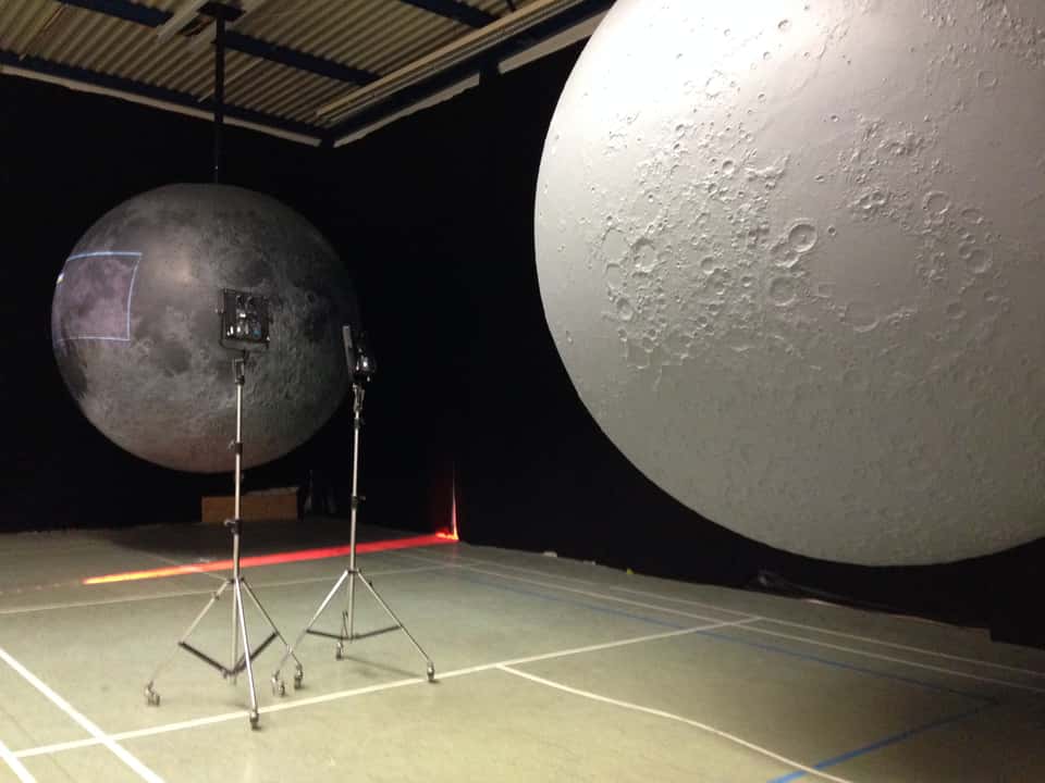
Test setup: Two physical moon models with live projection and synchronized rotation, used for development and calibration of the Moontable system. 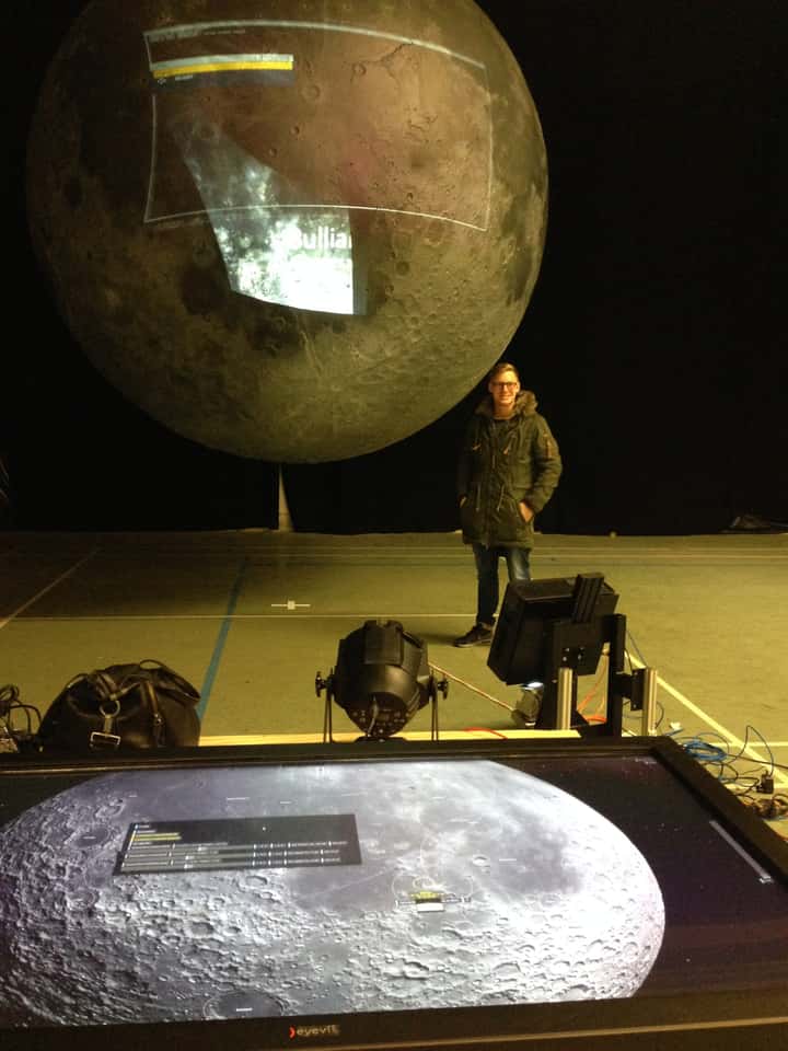


My Role & Key Contributions
I was responsible for the entire technical conception and implementation of the system, end-to-end.
Key contributions included:
- Full Unity-based application architecture and implementation
- Large-scale scientific data ingestion, cleaning, restructuring, and optimization
- Development of a planetary LOD system comparable to large-scale geospatial platforms
- Custom GPU shader development for real-time surface deformation from elevation data
- Design and implementation of the complete multi-touch user interface
- Database design and integration for lunar metadata and media assets
- Real-time communication architecture for physical-digital synchronization
- Definition and implementation of an MQTT-based control and messaging protocol
- Direct collaboration with international lunar scientists and data providers (including NASA sources)
- Coordination with external teams responsible for the physical moon fabrication
- Remote system installation and commissioning support


Technical Direction & Characteristics
At its core, Moontable is a real-time planetary rendering system operating under strict performance and longevity constraints.
Key technical characteristics:
- Data scale: Several hundred gigabytes of raw lunar elevation data (≈ 1 m spatial resolution)
- Rendering strategy: View-dependent, real-time tessellation of a spherical mesh, driven by camera distance and orientation
- GPU processing: Custom vertex and compute shaders for efficient height-field–based surface deformation directly on the graphics card
- LOD architecture: Hierarchical, tile-based data structure inspired by large-scale geospatial mapping systems, enabling seamless streaming and interaction
- Mathematics & simulation:
- Spherical geodesy for distance and relationship calculations on a planetary surface
- Great-circle distance calculations for accurate shortest-path measurements
- Spherical coordinate systems for mapping latitude/longitude data onto a 3D globe
- Astronomical sun–moon angle computation for physically accurate lighting simulation across time
- Data systems: Custom-designed database storing crater metadata, scientific attributes, imagery, video, and textual references, queried dynamically by the application
- System integration: Central MQTT-based messaging architecture coordinating application state, physical moon rotation, and real-time projection alignment
- Operational design: Engineered for permanent installation, continuous operation, and long-term maintainability
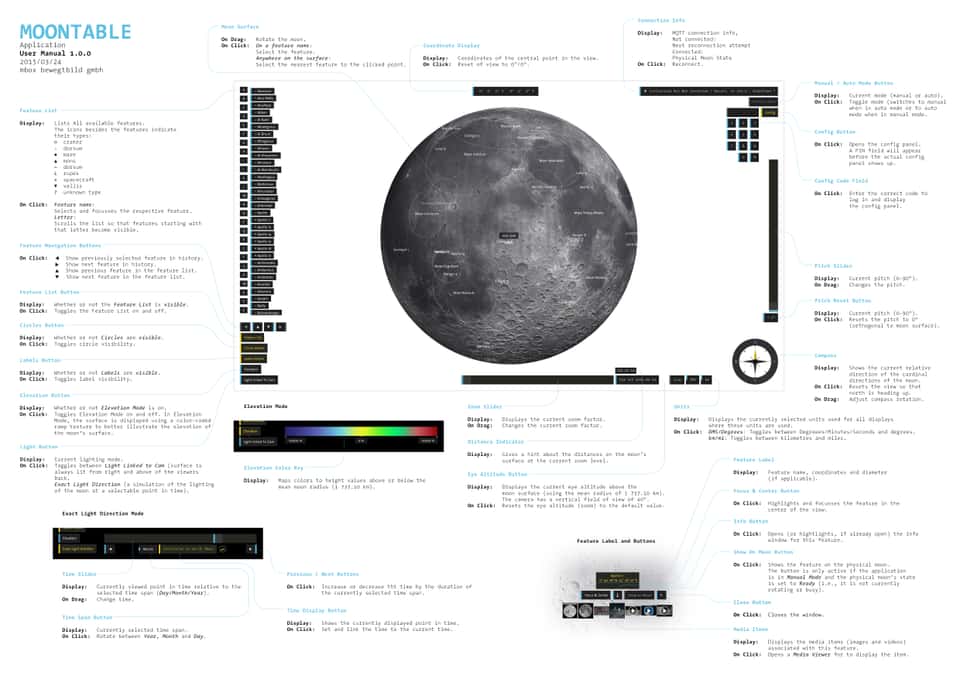
Excerpts from the user manual for the Moontable installation, providing instructions for interacting with the multi-touch table and exploring the lunar visualization.

Why This Project Matters
Moontable demonstrates how planetary-scale scientific datasets can be transformed into intuitive, real-time, spatial experiences without sacrificing accuracy or performance.
It bridges data science, GPU-driven rendering, and physical installation design—resulting in a system that makes complex astronomical data tangible, explorable, and enduring.